
Looking Back at Extreme Summer Weather
Canada has seen it all this summer: snow in the Jasper region, blazing forest fires, and a tornado in Alberta.
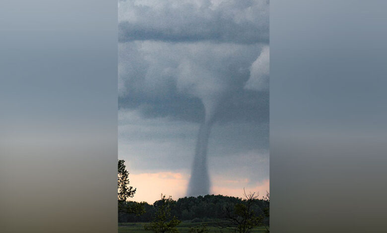
In fact, the recent Alberta tornado was one of the strongest recorded in Canada’s history, with winds powerful enough to launch a combine weighing nearly 10,000 kilograms into the air. To give you an idea of how strong that is, tornado simulators are often not able to life combines during studies because they aren’t strong enough.
The Northern Tornadoes Project rated the tornado as an EF-4, which is on the high end of the enhanced Fujita scale, which tops out at EF-5.
Environment Canada said the funnel cloud was formed by a supercell thunderstorm and lasted about a half-hour, with top winds hitting around 275 km/h.
Not since 1987 had such a powerful tornado descended on Alberta. In July of that year, an F-4 ripped through eastern Edmonton, killing 27 people and leaving more than 300 others injured. Edmontonians remember the event as “Black Friday.”
The only other F-4 recorded in the province happened in the Grassy Lake area in 1915.
The last F-3 tornadoes occurred in 2000. On July 14 of that year, the Pine Lake tornado struck a trailer park, killing 12 people and injuring more than 100 others.
So with all the extreme weather happening, let’s take a look back at our Province’s extreme weather over the years.
Regina tornado (June 30, 1912)
It was hot and muggy on June 30, 1912. Wascana Park was bustling with people soaking up the heat.
But what started as a beautiful summer day took a turn. Just before 5 p.m. CST, the clouds started to build with a dangerous green tinge.
Then, a strong cyclone touched down south of Regina. It travelled north, tearing through neighbourhoods north of Wascana Lake and the downtown.
This tornado is ranked as the deadliest cyclone in Canadian history. Twenty-eight people lost their lives and hundreds were injured. Houses and businesses were flattened, leaving $1.2 million in property damage and 2,500 people without homes.
Hottest temperature in Canada (July 5, 1937)
Though southern Ontario is known for its hot summers, Saskatchewan has its own place in the record books.
On July 5, 1937, the mercury rose to 45 C in both Yellow Grass and Midale, Sask., which is the hottest temperature officially recorded in Canada.
Yellow Grass is 75 kilometres southeast of Regina. Midale is 150 kilometres southeast of Regina.
Kamsack cyclone (Aug. 9, 1944)
On Aug. 9, 1944, when most eyes were on Europe, the skies opened up over Kamsack, Sask., northeast of Yorkton by the Manitoba border.
A powerful tornado ripped through the small town, killing three people and injuring many others. The twister destroyed 400 houses,100 businesses and caused $2 million in damages.
Veterans returning from overseas came home to a different battleground: helping with the community’s rebuild. This led to the community’s biggest building boom in its history.
Prairie drought of 1988
From too much snow to not enough precipitation, the summer of 1988 was marked by extreme drought conditions.
By June, record hot temperatures in the 40 C range set up in Saskatchewan and many communities only saw half their average rainfall.
Erosion of the dry soil was a problem and dust storms rolled across the parched prairies. The summer yielded a significant drop in crop production, with a loss of $1.8 billion in 1981 dollars.
Saskatoon thunderstorm (July 4, 1996)
On July 4, 1996, a powerful outbreak of thunderstorms led to numerous reported tornadoes and microbursts near Saskatoon, Maymont and Osler, Sask.
Winds in Saskatoon gusted between 120 and 140 km/h, causing damage to homes on the east side of the city and a drive-in theatre.
Vanguard storm (July 3, 2000)
During a series of severe thunderstorms in the summer of 2000, the community of Vanguard, Sask., saw what Environment Canada called the most intense rain storm ever on the Prairies.
On July 3, 2000, around 375 millimetres of rain fell near the small community southeast of Swift Current, Sask., in an eight-hour period. That’s more precipitation than the area typically sees in the entire year.
The storm washed out homes and roads in the community.
Saskatchewan floods (May and June 2011)
In May 2011, after a thick snowpack the previous winter, many communities saw their average annual rainfall fall in the span of a couple months.
Flash flooding between the Souris River and Assiniboine River began in early May. By June 17, Weyburn was one of 19 Saskatchewan communities to declare a state of emergency.
This flooding in southern Saskatchewan caused the evacuation of hundreds of residents and many highway closures, including part of the Trans-Canada. The flooding also displaced residents and caused extensive damage for those in southern Manitoba and North Dakota.
La Ronge wildfires (Summer 2015)
It was the largest evacuation in Saskatchewan’s history. In July 2015, more than 13,000 residents were forced from their homes as wildfires ravaged northern Saskatchewan.
The summer was unusually dry in the northern stretches of the province. Add a couple of lightning strikes, and the parched vegetation lit up.
By July 6, 112 fires were roaring in the province. Some of those fires infringed on populated areas, including the town of La Ronge, Sask., forcing mass evacuations.
Fire crews and soldiers from across Canada travelled to northern Saskatchewan to help fight the blazes.
By August, the fire situation had eased considerably, though many wildfires continued to burn into the fall.
Google Play and the Google Play logo are trademarks of Google LLC.